21 MARTEL RD
Owner Information
BECKETT LOUIS M
21 MARTEL RD
SOUTH HAMILTON, MA 01982


Property Details
21 MARTEL RD is classified as a Single Family Residential (Colonial).
The primary structure on this property was built in 1961. There are 2,436ft2 of built area within this property. There is 2,436ft2 of residential/living space within this property.
21 MARTEL RD is valued at $613,500. The land is valued at $281,600 and the structures are valued at $330,700. There is an additional valuation of $1,200 on this property.
This property is in Zone R1A. Confirm with local Zoning Board authorities to ensure there are no overlays or other easements on this property.
21 MARTEL RD was last sold on Friday, February 27, 1998 for $277,500.
Assessment data from fiscal year 2022.
Flood Data
According to the FEMA National Flood Hazard Layer, this property does not appear to be in a flood zone. It may also be in an area not yet reviewed. Nonetheless, confirm this information prior to taking any action.
To view the flood hazards around this property, create a FEMA "Firmette" Map of the area around 21 MARTEL RD.
Broadband Internet Providers
| Provider | Type | Bandwidth (mbps) | |
|---|---|---|---|
| HughesNet | Satellite | 25 | 3 |
| Viasat Inc | Satellite | 100 | 3 |
| VSAT Systems, LLC. | Satellite | 2 | 1 |
| Verizon New England Inc. | Fiber | 940 | 880 |
| Comcast | Cable | 1000 | 35 |
| T-Mobile | Fixed Wireless | 25 | 3 |
| GCI Communication Corp. | Satellite | 0 | 0 |
Broadband service provider data from December 2020.
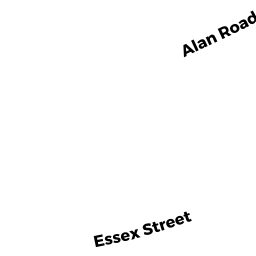
Adjacent Properties
- 226 ESSEX ST
Single Family Residential owned by FECTEAU DOUGLAS A & GABRIELLE H TRS - 27 MARTEL RD
Single Family Residential owned by GRINNELL ROBERT E - 234 ESSEX ST
Single Family Residential owned by WINSLOW CHRISTOPHER C & MARY C TR - 11 MARTEL RD
Single Family Residential owned by PARADISO JOSEPH F - 3 MARTEL RD
Single Family Residential owned by MAHANEY JOHN M TRUSTEE